Wednesday, April 22

Sam's Town RV Park Las Vegas, NV
 $36.26 per night
 We took a slightly different route to Las Vegas than we did last time. It has been very hot today, upper 90's. This evening we had dinner at the buffet in the Sam's Town Casino, then went to watch an indoor show of fountains, lasers and animated animals. Quite impressive for a small show, small for Las Vegas that is. If you are in Las Vegas I recommend this little free show, but see this one before going seeing the fountains of Bellagio else this one will seem a disappointment. We took a slightly different route to Las Vegas than we did last time. It has been very hot today, upper 90's. This evening we had dinner at the buffet in the Sam's Town Casino, then went to watch an indoor show of fountains, lasers and animated animals. Quite impressive for a small show, small for Las Vegas that is. If you are in Las Vegas I recommend this little free show, but see this one before going seeing the fountains of Bellagio else this one will seem a disappointment.
Thursday, April 23
We began today with some errands and shopping. Whole Foods, Frys electronics where we bought a small fan and a replacement antenna for our XM radio which got damaged yesterday at the wash. Later in the evening we went to see Cirque Du Soleil's KA. While the story wasn't quite as exciting as the others we have seen, the set design was worth the ticket price all by itself. The artists were fantastic, but they were just a bit overwhelmed by the set, stage and special effects. But the show is well worth seeing. If you get to Vegas, I recommend you see 3 Cirque Du Soleil shows in the following order, KA, Mystere, and O. That would put the biggest and most exciting near at the end. Otherwise you might be disappointed as you go along. We have not see the others yet so I can't place them in order. We had a nice dinner (buffet) at the campground's casino. Sam's Town is a major casino/hotel complex which had a buffet, a top-notch Steakhouse in an Aussie style; a Mexican Restaurant; TGIF Friday's; a Panda Express; a McDonald's; a Subway shop; and ancillary food places. So they are not lacking in restaurant facilities....all within a ten minute walk from our trailer.
Friday, April 24
Frank wants to apologize for the delay in posting. He is finding that staying in one place more than a few days gets boring and he has had a lot of trouble getting the motivation to do daily logs. Today Frank worked on the electronics of the trailer, such as a new antennae for the XM radio, and Tom did laundry. We loafed around the trailer before heading out to see Cirque Du Soleil's "O". We saw this show a few months earlier, but it is worth seeing again. Unfortunately, we asked for tickets so late be were in the upper, upper tiers of seats against the back wall and near the roof and our noses almost bled, but the show is spectacular from any vantage point and worth it. We got home and both of us stayed up until after 1 AM, which is most unusual...especially for Tom.
Saturday, April 25
We are two guys who form habits, so Tom did laundry again (sheets), and Frank worked on web pages. Tom also went casino hopping, which Frank finds boring. After seven days at casinos (Laughlin, NV and Las Vegas, NV, Tom walked away as a $5 winner...so you can see he is a high roller....or maybe the term is fast slot machine puller. For dinner tonight we met our friend Jody who lives in Las Vegas. Jody is always fun to visit with. We dined at the Black Angus which is an excellent restaurant.
Sunday, April 26
Again, since we are habit formers, we returned to Fry's electronics and Whole Foods. Frank bought three new web cams for reviewing...which probably brings him to hundreds by now. Then returned to the trailer and Frank worked on a power supply for the XM radio to eliminate an AC hum the original hook was causing. Tom again when casino hopping. We ate diner at the casino's buffet...not as good as the other night. The only dessert that Frank could eat was burnt so that helping got left on the table. When Tom paid the check as we walked in, the cashier handed him some paper which he placed in his pocket thinking it was a copy of the bill. Not until Monday morning did he realize the paper was a chit for two free glasses of wine or two free beers. These may have brightened up the burnt desserts...at least for Tom.
|


 Not a bad KOA but a bit pricey for a desert all gravel campground. We spent the afternoon rebuilding the slide out pantry which had broken several weeks ago. We had to tear out the thin floor which was nothing more than a thin piece of cheap paneling and replace it with some plywood. Later we drove through the town of Lordsburg. Very depressed, mostly empty buildings and houses. We tried driving out of town a ways to take a back route to the campground, but the roads our map indicated were there weren't. We did see an interesting historical marker about a Camp Lordsburg.
 Wonderful campground. The photo makes it look like it is empty, but they are full. That goes to show how nice it is. Wide spaces and lots of trees. We had a problem when we hooked up the power. We blew out a surge protector and apparently a printer (although that has yet to be confirmed). Apparently Frank's wireless network card is also damaged as he is unable to get a decent connection to the Internet. Tomorrow's first trip will include a visit to Best Buy to find replacements. Check out these 2 photos from the air shot by Frank's father back in 1946 while he was stationed at Fort Bliss.
  We are on the move again, now in Central time, headed for the Big Bend region of southern Texas. This morning as we were closing camp, we found the wind from the last few days had actually moved the trailer a couple of feet. This had managed to bend one of our front jacks as well as some damage to our electrical hookup. We were unable to retract the jack completely, but enough so we can continue to travel until we can find a place to have it repaired. This campground is fairly nice, great views of the desert and surrounding mountains, and very friendly office staff. Here are a couple of cute photos around the campground.
  (Our Internet connection through our cellular provider in this campground is so slow that I am unable to upload any photos or prepare the Google Earth placemarks, so those will be added in a few days when we get to an area with a better connection)
  This is a beautiful campground with amazing vistas in all directions. After breaking camp we headed south through Marfa Texas, the site of the famous Marfa lights. W
  We awoke this morning to hazy skies. The view was terrible, you could only see about 50 miles! For those of you in the eastern US, that might sound grand but the normal visibility around here should be from 100 to 150 miles. As we went further north, the air did clear just a bit and we did see a nice view as we came over a rise.
  Today we moved northward to Hobbs New Mexico then turned west. For most of the day we were traveling through the great Permian Basin W which we just touched in February. If you take a look at our daily route on Google Earth and zoom in a bit you can see the thousands of evenly spaced oil wells all through the area. Along the way we stopped at the border of New Mexico and took a look at a Texas monument. Frank remembers climbing on one of these back in the late 1960's on a trip with his family. We passed a huge cowboy sculpture and got a photo. Later we looked at the sculpture on their website. J We stopped in the town of Hobbs to switch drivers and Frank took a shot of an empty building with a mural painted on the front.
  A very nice drive today through some beautiful mountains. Unfortunately, Frank had the camera set for special lighting and none of our images came out so we are substituting a few webcam shots in the gallery. We are in a Bureau of Land Management (BLM) campground. We were in the same campground back in 1990 but back then it was a state park. The BLM has done a great job of fixing up the place. This is an area that had volcanic lava flows some 3,000 to 5,000 years ago. We took a short hike on a nice accessible nature trail where most of the photos in today's gallery were shot.
  After packing up we headed west along US 60. Not too far from where we had camped we passed near Trinity Site, where on July 16, 1945 the world's first atomic bomb was detonated.
  Another fantastic campground. Concrete roadways and sites, full hookups but only 30 amp service, but we can deal with low electric. It has been extremely windy today with gusts as high as 60 mph. It is supposed to get down to the 20s tonight. We had a bit of trouble starting the truck this morning. I think it may have been the cold weather and the 7,500 foot elevation. Something happened back home in Virginia last night and the home servers are off line. That means no webcams until we can figure what the problem is.
 Last night the temp got down to around 24 degrees. This morning as we prepared to depart, as yesterday we were unable to get the truck started. We even had to pull out the battery charger because we began to run the truck battery down. but persistence prevailed and eventually we got it started, after about an hour. We are thinking that there is something wrong with the glow plugs in the diesel engine. Today's route was quite spectacular, as we traveled along US 60. Beautiful canyons and mountains everywhere. Then came the best part as we dropped into the Salt River Valley. Just look at the photos and I think you will agree.
  We are back in the same campground we were in last February. But this site is not as nice. Cramped, too close together. We have about a foot on each side. What makes it worse is the campground is less than half full. We had dinner at the casino buffet, but the food was over cooked and dry. Cost was the same as Old Country Buffet which we like.
 We left Sam's Town RV and Las Vegas, NV behind and headed south west to Barstow, CA. Near 90 degrees temperature and it is only April. Our highlight of the day was when we entered California. About 50 miles inside the border all traffic had to pass through an Agricultural Inspection Station.
  We are back in the same campground and site we were 5 weeks ago. Tonight it will be windy and the temperature is expected to drop near 40. Last night, while browsing Google Earth, Frank found a local museum called the Desert Discovery Center in Barstow. We debated on staying another day but looking at their website, we can't tell if they have anything to go see, other than a large meteor, so we decided to move on.
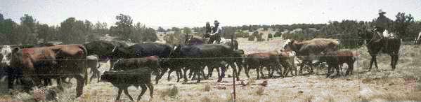
 We are now near Palm Springs California. This coming weekend is the Hot Rodeo about a mile from this campground. Frank also has another IGRA board meeting this Friday which will be webcast.